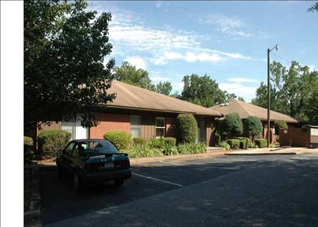
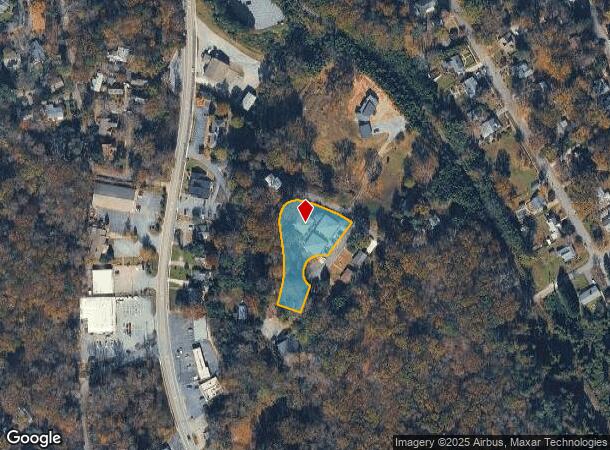
Property Record
20 Viewmont St, Tryon, NC 28782
NEARBY LISTINGS FOR SALE OR LEASE
-
-
View all Tryon listings for sale on LoopNet.com
Property Detail
20 Viewmont St
T9-C25
Viewmont Heights
Realpropertynec
LOTS 8 - 11, VIEWMONT APTS, 0V04 VIEWMONT HEIGHTS 09
X
Polk
45083C0005D
North Carolina
2025
8-11
2025
1.02 AC
920304
North Carolina West/Cherokee Area
2,500 SF
Other Market Areas
DEMOGRAPHICS near 20 Viewmont St
1 Mile
3 Mile
5 Mile
2024 Total Population
2,211
6,958
14,141
2029 Population
2,448
7,700
15,698
Pop Growth 2024-2029
+ 10.72%
+ 10.66%
+ 11.01%
Average Age
53
51
49
2024 Total Households
1,131
3,254
6,388
HH Growth 2024-2029
+ 10.61%
+ 10.66%
+ 11.08%
Median Household Inc
$51,623
$55,198
$54,897
Avg Household Size
1.90
2.10
2.10
2024 Avg HH Vehicles
2.00
2.00
2.00
Median Home Value
$337,419
$287,477
$257,294
Median Year Built
1978
1979
1979
Nearby Places
Map Layers
Map Styles
 Street
 Aerial
- Restaurants
- Banks
- Shops
- Fitness
- Groceries
PUBLIC TRANSPORTATION
AIRPORT
Greenville Spartanburg International
DRIVE
WALK
Distance
Greenville Spartanburg International
43 min
24.9 mi
Asheville Regional
DRIVE
WALK
Distance
Asheville Regional
43 min
31.3 mi
Nearby Properties
Address
Land Use
TOTAL SIZE
Lot Size
Zoning
Address
Land Use
TOTAL SIZE
Lot Size
Zoning
68,155 SF
63.56 AC
MX
Address
Land Use
TOTAL SIZE
Lot Size
Zoning
92,600 SF
15.84 AC
MX
Address
Land Use
TOTAL SIZE
Lot Size
Zoning
13 AC
M
Address
Land Use
TOTAL SIZE
Lot Size
Zoning
16,744 SF
7.58 AC
M
Address
Land Use
TOTAL SIZE
Lot Size
Zoning
8,095 SF
0.53 AC
M
Address
Land Use
TOTAL SIZE
Lot Size
Zoning
14,926 SF
4.48 AC
M
Address
Land Use
TOTAL SIZE
Lot Size
Zoning
6,735 SF
8.20 AC
M
Address
Land Use
TOTAL SIZE
Lot Size
Zoning
450.29 AC
Address
Land Use
TOTAL SIZE
Lot Size
Zoning
15,450 SF
3 AC
M
Address
Land Use
TOTAL SIZE
Lot Size
Zoning
2,796 SF
7.95 AC
M
Address
Land Use
TOTAL SIZE
Lot Size
Zoning
8,986 SF
1.15 AC
M
Address
Land Use
TOTAL SIZE
Lot Size
Zoning
7,204 SF
5.25 AC
M
Address
Land Use
TOTAL SIZE
Lot Size
Zoning
6,688 SF
1.25 AC
M
Address
Land Use
TOTAL SIZE
Lot Size
Zoning
4,368 SF
3.71 AC
M
Address
Land Use
TOTAL SIZE
Lot Size
Zoning
28.12 AC
M
Address
Land Use
TOTAL SIZE
Lot Size
Zoning
318.36 AC
MX
Address
Land Use
TOTAL SIZE
Lot Size
Zoning
7,316 SF
3.01 AC
M
Address
Land Use
TOTAL SIZE
Lot Size
Zoning
6,443 SF
0.72 AC
M
Address
Land Use
TOTAL SIZE
Lot Size
Zoning
4,432 SF
8.05 AC
M
Address
Land Use
TOTAL SIZE
Lot Size
Zoning
289.30 AC
UNZONED
Address
Land Use
TOTAL SIZE
Lot Size
Zoning
122.29 AC
MX
Address
Land Use
TOTAL SIZE
Lot Size
Zoning
10,000 SF
10.63 AC
M
Address
Land Use
TOTAL SIZE
Lot Size
Zoning
2,125 SF
6.17 AC
M
Address
Land Use
TOTAL SIZE
Lot Size
Zoning
220 AC
MX
Address
Land Use
TOTAL SIZE
Lot Size
Zoning
2,334 SF
126.27 AC
M
Address
Land Use
TOTAL SIZE
Lot Size
Zoning
16,552 SF
2.15 AC
M
Address
Land Use
TOTAL SIZE
Lot Size
Zoning
33.88 AC
MX
Address
Land Use
TOTAL SIZE
Lot Size
Zoning
5,360 SF
0.68 AC
M
Address
Land Use
TOTAL SIZE
Lot Size
Zoning
10,624 SF
2.39 AC
M
Address
Land Use
TOTAL SIZE
Lot Size
Zoning
3,556 SF
8.40 AC
NC
The World's #1 Commercial Real Estate Marketplace
Connect with us
© 2025 CoStar Group
The information above has been obtained from sources believed reliable. While we do not doubt its accuracy we have not verified it and make no guarantee, warranty or representation about it. It is your responsibility to independently confirm its accuracy and completeness. Any projections, opinions, assumptions, or estimates used are for example only and do not represent the current or future performance of the property. The value of this transaction to you depends on tax and other factors which should be evaluated by your tax, financial, and legal advisors. You and your advisors should conduct a careful, independent investigation of the property to determine to your satisfaction the suitability of the property for your needs.